WEATHER STORY New Orleans/Baton Rouge Weather Forecast Office |
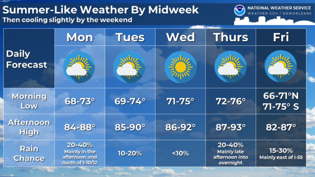
|
|||
![]() |
|||
National Weather Service New Orleans Preliminary Damage Survey Results
Kentwood to Darbun Tornado
Date - March 15th, 2025
Begin Time (Local) - 12:19 PM CT
End Time (Local) - 1:02 PM CT
EF Rating - EF-4
Est. Peak Winds - 170 mph
Path length - 35.45 miles*
Max Width - Unavailable
Injuries/Deaths - Unavailable/3
Map of the track which has a red line that goes northeast from Kentwood, LA to Darbun, MS. The track does continue into Marion county, but that is the responsibility of NWS Jackson MS so we did not survey past that area.
Text Narrative can be found here: https://partnerservices.nws.noaa.gov/products/4140f898b8b0099bc39fe27fb9a2d9da
|
Select a Different Office Below
Data Courtesy of New Orleans/Baton Rouge Weather Forecast Office