No Warnings, Watches, or Advisories
Visible Radar Visible Satellite
spacer
Updated: @ 16-Apr-2024 7:01am - next update at 12:00am  
Summary / Temperature Wind Rain Outlook
Moderate drizzle Moderate drizzle
Currently: 41.8°F, Max: 48.7°F, Min: 41.7°F 41.8°F
Colder 0.5°F than last hour.

---

Feels like: 33°F

24-hr difference
-7.1°FColder 7.1°F than yesterday at this time.
  Today Yesterday
High: 48.7°F
12:00am
64.4°F
5:20pm
Low: 41.7°F
7:00am
48.1°F
7:25am
 Wind from NE NE
21.4
Gust:
19 mph
6 Bft - Fresh Breeze
Today: 42.6 mph 6:52am
Gust Month: 54.1 mph April 10
Rain Today: 0.41 in
Rain Rate (/hr): 0.29 in
Rain Yesterday: 0.06 in
Storm Rain: 0.47 in
This Month: 0.83 in
Season Total: 2.17 in
1 rain day in April.
Tuesday

Tuesday: Showers And Thunderstorms then Rain
Showers And T-Storms then Rain
Humidity & Barometer Almanac Moon
Humidity: 80 % Increased 2.0% since last hour.
Dew Point: 36.1°F Increased 0.2°F since last hour.
Barometer: 29.421 inHg Falling 0.10  inHg/hr
Baro Trend: Falling rapidly
Sunrise: 6:52am
Sunset: 8:32pm
Moonset: 4:24am
Moonrise: 1:06pm
Waxing Gibbous
Waxing Gibbous, Moon at 8 days in cycle
57%
Illuminated
UV Index Solar Radiation
   0.0    None
High: 0.0 @ 12:00am
0 W/m2 (0 %)
High: 0 @  12:00am
National Weather Service History
Normal Rain Month:  1.34  in. Normal Rain YTD:  2.47  in.
Normal High:  56°F Normal Low:  31°F
Record High:  82°F  1906 Record Low:  -100°F  2022
 NWS Weather Forecast  - Outlook: Overnight & Tuesday
Overnight

Overnight: Showers And Thunderstorms
Showers And T-Storms

Lo 42 °F ↑
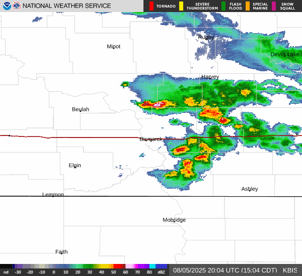
NWS forecast: Showers and thunderstorms. Cloudy. Low around 42, with temperatures rising to around 46 overnight. Northeast wind around 16 mph, with gusts as high as 26 mph. Chance of precipitation is 100%. New rainfall amounts between a quarter and half of an inch possible.
Davis VP+ forecast: Increasing clouds and cooler, precipitation possible within 6 hrs, windy with possible wind shift to the w, nw, or n.
 
Tuesday

Tuesday: Showers And Thunderstorms then Rain
Showers And T-Storms then Rain

Hi 50 °F ↓
NWS forecast: Showers and thunderstorms before 8am, then rain and a slight chance of thunderstorms. Cloudy. High near 50, with temperatures falling to around 48 in the afternoon. Northeast wind 13 to 20 mph, with gusts as high as 30 mph. Chance of precipitation is 100%. New rainfall amounts between a half and three quarters of an inch possible.